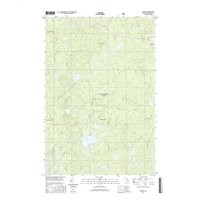
2017 Map of Gogebic
USGS Topo · Published 2017About this map
Pomeroy Lake and Little Pomeroy Lake form the center of this hydrographic network within the Ottawa National Forest. The landscape is defined by its glacial kettle lakes and a dense system of waterways, including the East Branch Presque Isle River and Pelton River. The tiny settlement of Gogebic sits on the eastern edge of the quadrangle, serving as a rare point of human habitation in a region primarily dedicated to timber management and outdoor recreation. A complex grid of Forest Service roads, such as Nfst-6818 and Nfst-6822, provides access across the townships of T45N R42W and T46N R42W. The presence of the Bluebill Creek Hunter trail and numerous smaller bodies of water like Holly Lake and Saint Augustine Lake highlights the area's use for seasonal wilderness activities and conservation.
Find a feature on this map
95 named features on this map. Tap any name to fly to it.
Don’t see what you’re looking for? This feature index may not catch every label — zoom into the map to look around manually.
Map Details
Editions of this 2017 Gogebic Map
This is the sole edition of this map. No revisions or reprints were ever made.
Other maps of this area

1939 · Trout Lake
USGS Topo · 1:48,000

1946 · Star Lake
USGS Topo · 1:48,000

1946 · Trout Lake
USGS Topo · 1:48,000

1949 · Trout Lake
USGS Topo · 1:48,000

1950 · Star Lake
USGS Topo · 1:48,000

1952 · Thayer
USGS Topo · 1:62,500

1955 · Marenisco
USGS Topo · 1:62,500

1955 · Starlake
USGS Topo · 1:62,500

1955 · Boulder Junction
USGS Topo · 1:62,500

1955 · Marenisco
USGS Topo · 1:24,000