
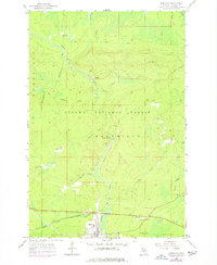
1955 Map of Marenisco
USGS Topo · Published 1957About this map
Marenisco serves as the primary hub for this portion of Gogebic County, situated where the Chicago and North Western rail line meets the waters of the Presque Isle River. The mid-century landscape is defined by the heavy timber of the Ottawa National Forest and an extensive network of waterways including Kinnickinnic Creek, Bingham Creek, and Wolf Mountain Cr. Evidence of the region's industrial transitions is visible in the numerous segments of Old Railroad Grade and sections labeled Abandoned, which mark the former paths of logging and mineral transport. Public safety and aviation infrastructure are represented by the Marenisco Lookout Tower and the Marenisco Landing Field, while the smaller settlements of Ethelwood and Theilers provide a record of early northern Michigan community development. The presence of Yondota Falls and several Gravel Pit locations further highlights the area's natural geography and resource extraction history.
Find a feature on this map
26 named features on this map. Tap any name to fly to it.
Don’t see what you’re looking for? This feature index may not catch every label — zoom into the map to look around manually.
Map Details
Editions of this 1955 Marenisco Map
2 editions found
Other maps of this area

1955 · Marenisco
USGS Topo · 1:62,500

1955 · Wakefield
USGS Topo · 1:62,500

1955 · Wakefield NE
USGS Topo · 1:24,000

1956 · Bergland
USGS Topo · 1:62,500

1956 · Thomaston
USGS Topo · 1:62,500

1958 · Iron River
USGS Topo · 1:250,000

1960 · Iron River
USGS Topo · 1:250,000

1961 · Iron River
USGS Topo · 1:250,000

1967 · Iron River
USGS Topo · 1:250,000

1979 · Ontonagon
USGS Topo · 1:100,000