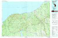
1979 Map of Ontonagon
USGS Topo · Published 1991About this map
Lake Superior defines the northern coastline of this Western Upper Peninsula landscape, where the Porcupine Mountains rise sharply from the water's edge. The 1970s interior reveals a network of logging and mining communities connected by the Soo Line railroad and a grid of forestry roads. Deep within the Ottawa National Forest, the map captures the industrial and natural intersection of the region, from the active copper operations near White Pine to the historic settlement at Victoria. The drainage patterns of the Ontonagon River and its multiple branches dominate the central terrain, feeding into the Victoria Reservoir. Small hamlets like Matchwood and Greenland serve as local hubs for the surrounding timberlands, while the southern shore of Lake Gogebic provides a primary recreational focal point at Bergland.
Find a feature on this map
73 named features on this map. Tap any name to fly to it.
Don’t see what you’re looking for? This feature index may not catch every label — zoom into the map to look around manually.
Map Details
Editions of this 1979 Ontonagon Map
This is the sole edition of this map. No revisions or reprints were ever made.
Historical Maps of Ontonagon Through Time
Featured Locations
- Bergland, Bergland Township
- Matchwood, Matchwood Township
- Rockland, Rockland Township
- Greenland, Greenland Township
- Ontonagon, Ontonagon Township