
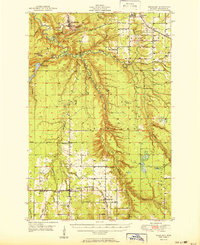
1951 Map of Rockland
USGS Topo · Published 1951About this map
Rockland and its surrounding copper mining landscapes are documented here at mid-century, shortly after field checks in 1949. The terrain is defined by the branching corridors of the Ontonagon River, including the East Branch Ontonagon River and Middle Branch Ontonagon River. Industrial and transportation infrastructure is prominent, featuring the Chic Ago Milwaukee ST Paul And Pacific railroad and localized mining landmarks like C Shaft Hill. Smaller settlements such as Victoria and Bruce Crossing anchor the rural landscape, which is dotted with community centers like Wainola Ch and several burial grounds, including Irish Hollow Cem and Woodlawn Cem.
Find a feature on this map
49 named features on this map. Tap any name to fly to it.
Don’t see what you’re looking for? This feature index may not catch every label — zoom into the map to look around manually.
Map Details
Editions of this 1951 Rockland Map
2 editions found
Other maps of this area

1949 · Rockland
USGS Topo · 1:62,500

1950 · Greenland
USGS Topo · 1:62,500

1951 · Greenland
USGS Topo · 1:62,500

1952 · Watersmeet
USGS Topo · 1:62,500

1952 · Thayer
USGS Topo · 1:62,500

1954 · Rousseau
USGS Topo · 1:62,500

1954 · Kenton
USGS Topo · 1:62,500

1954 · Winona
USGS Topo · 1:62,500

1955 · Ontonagon
USGS Topo · 1:62,500

1956 · Matchwood
USGS Topo · 1:62,500