
1955 Map of Ontonagon
USGS Topo · Published 1956About this map
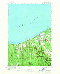
The mouth of the Ontonagon River serves as the focal point for this mid-century survey of Michigan's western Upper Peninsula coastline. The village of Ontonagon is depicted with detailed infrastructure including a Lighthouse, Schuster Field, and the Township Park along the shore of Lake Superior. The influence of the timber and transport industries is evident in the rail lines of the Chicago Milwaukee St. Paul and Pacific and the presence of small settlements like Green, Wood Spur, and Austin. To the south, the landscape transitions into the heavily wooded tracts of the Ottawa National Forest and Baraga State Forest, where numerous waterways like the Floodwood River and Cranberry River cut through the terrain. Genealogists may find particular interest in the Carp Lake Sch (Aband) and the local burials at Riverside Cem and Evergreen Cem.
Find a feature on this map
39 named features on this map. Tap any name to fly to it.
Don’t see what you’re looking for? This feature index may not catch every label — zoom into the map to look around manually.
Map Details
Editions of this 1955 Ontonagon Map
2 editions found
Other maps of this area

1949 · Matchwood NW
USGS Topo · 1:24,000

1949 · White Pine
USGS Topo · 1:24,000

1949 · Bergland NE
USGS Topo · 1:24,000

1949 · Rockland
USGS Topo · 1:62,500

1950 · Greenland
USGS Topo · 1:62,500

1951 · Rockland
USGS Topo · 1:62,500

1951 · Greenland
USGS Topo · 1:62,500

1956 · Bergland NE
USGS Topo · 1:24,000

1956 · Bergland
USGS Topo · 1:62,500

1956 · White Pine
USGS Topo · 1:24,000