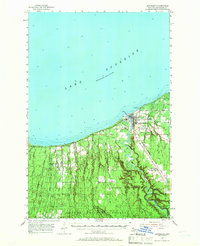
1955 Map of Ontonagon
USGS Topo · Published 1966About this map
Lake Superior dominates the northern horizon of this mid-century survey, its deep waters meeting the rocky shoreline where the Ontonagon River flows into the lake. The village of Ontonagon serves as the focal point of the region, positioned at the river's mouth and featuring maritime and aviation infrastructure like the Lighthouse and Schuster Field. Moving inland, the landscape is defined by the dense woodlands of the Ottawa National Forest and Baraga State Forest, divided by the prominent Carp Lake Ridge.
Find a feature on this map
27 named features on this map. Tap any name to fly to it.
Don’t see what you’re looking for? This feature index may not catch every label — zoom into the map to look around manually.
Map Details
Editions of this 1955 Ontonagon Map
2 editions found
Other maps of this area

1949 · Matchwood NW
USGS Topo · 1:24,000

1949 · White Pine
USGS Topo · 1:24,000

1949 · Bergland NE
USGS Topo · 1:24,000

1949 · Rockland
USGS Topo · 1:62,500

1950 · Greenland
USGS Topo · 1:62,500

1951 · Rockland
USGS Topo · 1:62,500

1951 · Greenland
USGS Topo · 1:62,500

1955 · Ontonagon
USGS Topo · 1:62,500

1956 · Bergland NE
USGS Topo · 1:24,000

1956 · Bergland
USGS Topo · 1:62,500