
1956 Map of Matchwood
USGS Topo · Published 1958About this map
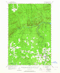
Ottawa National Forest dominates this mid-century landscape in Ontonagon County, where timber and transit intersect. The Duluth South Shore and Atlantic railroad corridor serves as the primary East-West axis, connecting the small settlements of Topaz, Matchwood, and Ewen. This corridor represents the area's mid-20th-century economic lifeblood, facilitating the movement of resources through the northern woods.
Find a feature on this map
59 named features on this map. Tap any name to fly to it.
Don’t see what you’re looking for? This feature index may not catch every label — zoom into the map to look around manually.
Map Details
Editions of this 1956 Matchwood Map
2 editions found
Other maps of this area

1949 · Matchwood NW
USGS Topo · 1:24,000

1949 · White Pine
USGS Topo · 1:24,000

1949 · Bergland NE
USGS Topo · 1:24,000

1949 · Rockland
USGS Topo · 1:62,500

1950 · Greenland
USGS Topo · 1:62,500

1951 · Rockland
USGS Topo · 1:62,500

1951 · Greenland
USGS Topo · 1:62,500

1952 · Watersmeet
USGS Topo · 1:62,500

1952 · Thayer
USGS Topo · 1:62,500

1955 · Ontonagon
USGS Topo · 1:62,500
Featured Places
- Matchwood, MI
- Marenisco Township, MI
- Ontonagon Township, MI
- Carp Lake Township, MI
- Rockland Township, MI