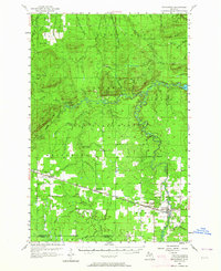
1956 Map of Matchwood
USGS Topo · Published 1964About this map
The West Branch Ontonagon River and South Branch Ontonagon River wind through the heart of the Ottawa National Forest in this mid-century survey of the Upper Peninsula. The landscape is defined by its industrial and transit history, featuring the Duluth South Shore and Atlantic railroad corridor connecting the settlements of Topaz, Matchwood, and Ewen. Historic extractive operations are evidenced by the Norwich Mine near the Norwich Lookout Tower, while the Victoria Reservoir in the northeast highlights the region's hydroelectric development. Numerous watercourses like the Little Cranberry River and Cascade Creek feed into the main river branches, alongside local landmarks such as Big Bear Airport and the prominent Oak Bluff. The presence of an Old Railroad Grade and a Flowing Well provide specific points of interest for those tracing the evolution of local infrastructure and land use.
Find a feature on this map
59 named features on this map. Tap any name to fly to it.
Don’t see what you’re looking for? This feature index may not catch every label — zoom into the map to look around manually.
Map Details
Editions of this 1956 Matchwood Map
2 editions found

Other maps of this area

1949 · Matchwood NW
USGS Topo · 1:24,000

1949 · White Pine
USGS Topo · 1:24,000

1949 · Bergland NE
USGS Topo · 1:24,000

1949 · Rockland
USGS Topo · 1:62,500

1950 · Greenland
USGS Topo · 1:62,500

1951 · Rockland
USGS Topo · 1:62,500

1951 · Greenland
USGS Topo · 1:62,500

1952 · Watersmeet
USGS Topo · 1:62,500

1952 · Thayer
USGS Topo · 1:62,500

1955 · Ontonagon
USGS Topo · 1:62,500
Featured Places
- Matchwood, MI
- Marenisco Township, MI
- Ontonagon Township, MI
- Carp Lake Township, MI
- Rockland Township, MI