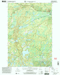
1999 Map of Gogebic
USGS Topo · Published 2004About this map
Ottawa National Forest dominates this northern Michigan landscape, characterized by a dense network of glacial lakes and river systems within the Marenisco boundary. The Slate River and Patton Creek drain the northern reaches, while the southern terrain is defined by a concentration of water bodies including Pomeroy Lake, Langford Lake, and Holly Lake. Settlement is sparse, centered on the community of Gogebic near the northeastern edge, where a Gravel Pit and utility Pipeline indicate local resource activity.
Find a feature on this map
30 named features on this map. Tap any name to fly to it.
Don’t see what you’re looking for? This feature index may not catch every label — zoom into the map to look around manually.
Map Details
Editions of this 1999 Gogebic Map
This is the sole edition of this map. No revisions or reprints were ever made.
Other maps of this area

1939 · Trout Lake
USGS Topo · 1:48,000

1946 · Star Lake
USGS Topo · 1:48,000

1946 · Trout Lake
USGS Topo · 1:48,000

1949 · Trout Lake
USGS Topo · 1:48,000

1950 · Star Lake
USGS Topo · 1:48,000

1952 · Thayer
USGS Topo · 1:62,500

1955 · Marenisco
USGS Topo · 1:62,500

1955 · Starlake
USGS Topo · 1:62,500

1955 · Boulder Junction
USGS Topo · 1:62,500

1955 · Marenisco
USGS Topo · 1:24,000