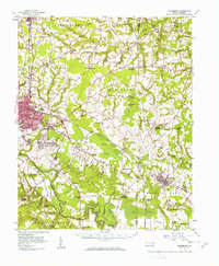
1957 Map of Goldsboro
USGS Topo · Published 1958About this map
The Seymour Johnson Air Force Base dominates the southern edge of Goldsboro in this late 1950s survey, marking a period of significant military presence and infrastructure expansion in Wayne County. To the east and west, the map details the suburban growth of neighborhoods like Webtown, Airboro, and Adamsville, while maintaining the distinct agricultural character of the surrounding countryside. This landscape is defined by the winding course of the Neuse River and its numerous tributaries, including Nahunta Swamp and Stony Creek, which historically dictated the placement of early mills and river-reliant industries.
Find a feature on this map
104 named features on this map. Tap any name to fly to it.
Don’t see what you’re looking for? This feature index may not catch every label — zoom into the map to look around manually.
Map Details
Editions of this 1957 Goldsboro Map
2 editions found

Other maps of this area

1902 · Kenly
USGS Topo · 1:62,500

1903 · Kenly
USGS Topo · 1:62,500

1904 · Falkland
USGS Topo · 1:62,500

1904 · Wilson
USGS Topo · 1:62,500

1914 · Kinston
USGS Topo · 1:48,000

1916 · Kinston
USGS Topo · 1:62,500

1953 · Rocky Mount
USGS Topo · 1:250,000

1953 · Raleigh
USGS Topo · 1:250,000

1954 · Rocky Mount
USGS Topo · 1:250,000

1954 · Raleigh
USGS Topo · 1:250,000