
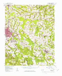
1957 Map of Goldsboro
USGS Topo · Published 1958About this map
Goldsboro serves as the focal point of this late 1950s survey, showing a landscape defined by the expansion of Seymour Johnson Air Force Base and the critical rail lines of the Atlantic Coast Line and Atlantic and East Carolina. To the southeast, the Neuse River winds through dense bottomlands, bordered by Indian Springs and Moseley Hall. The map documents a rural society deeply rooted in localized community hubs like Cokers Crossroads, Pikeville, and La Grange. Numerous country churches and schools, such as Invitation Sch, St Marys Sch, and Holly Green Ch, are scattered throughout the township divisions. This era shows the region just before significant interstate development, where the economy remains tied to the land, evidenced by several Sand Pits and Clay Pits dotting the outskirts of the primary settlements.
Find a feature on this map
94 named features on this map. Tap any name to fly to it.
Don’t see what you’re looking for? This feature index may not catch every label — zoom into the map to look around manually.
Map Details
Editions of this 1957 Goldsboro Map
2 editions found
Other maps of this area

1902 · Kenly
USGS Topo · 1:62,500

1903 · Kenly
USGS Topo · 1:62,500

1904 · Falkland
USGS Topo · 1:62,500

1904 · Wilson
USGS Topo · 1:62,500

1914 · Kinston
USGS Topo · 1:48,000

1916 · Kinston
USGS Topo · 1:62,500

1953 · Rocky Mount
USGS Topo · 1:250,000

1953 · Raleigh
USGS Topo · 1:250,000

1954 · Rocky Mount
USGS Topo · 1:250,000

1954 · Raleigh
USGS Topo · 1:250,000