
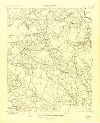
1904 Map of Falkland
USGS Topo · Published 1936About this map
The Tar River flows through the northeastern corner of this coastal plain landscape, where river landings like Dupree Ldg. once anchored local commerce. Surveyed in 1902, the area is defined by its extensive swamp systems, including Black Swamp, Middle Swamp, and Nahunta Swamp, which influence the placement of early settlements and roads. The industrial and agricultural heartbeat of the region is visible through features like Harris Millpond and Edson Millpond, along with the intersection of early transportation routes such as the Plank Road near Farmville. Small community centers and post offices like Fountain P.O., Toddy Sta., and Speights Bridge are linked by a network of rural lanes, reflecting the late 19th-century transition toward rail-and-road reliance over river transport.
Find a feature on this map
52 named features on this map. Tap any name to fly to it.
Don’t see what you’re looking for? This feature index may not catch every label — zoom into the map to look around manually.
Map Details
Editions of this 1904 Falkland Map
3 editions found
Other maps of this area

1901 · Parmele
USGS Topo · 1:62,500

1902 · Parmele
USGS Topo · 1:62,500

1902 · Ayden
USGS Topo · 1:62,500

1902 · Rocky Mount
USGS Topo · 1:62,500

1902 · Tarboro
USGS Topo · 1:62,500

1903 · Tarboro
USGS Topo · 1:62,500

1903 · Winterville
USGS Topo · 1:62,500

1904 · Ayden
USGS Topo · 1:62,500

1904 · Rocky Mount
USGS Topo · 1:62,500

1904 · Wilson
USGS Topo · 1:62,500