
1902 Map of Ayden
USGS Topo · Published 1962About this map
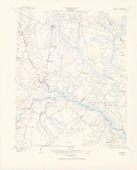
The Neuse River and Little Contentnea Creek define the low-lying geography of this eastern North Carolina region at the dawn of the twentieth century. Life here revolves around the water, evidenced by a dense network of landings along the Neuse, including Bectors Old Field Landing, Jollys Old Field Ldg., and Caswell Ldg., which served as critical points for the steamboat route. The map documents the overlap of traditional river transport with newer infrastructure, notably the Atlantic Coast Line railroad passing through Ayden and Grifton. Interior settlements like Johnsons Mills and Coxville sit among extensive swamp systems such as Clayroot Swamp and Indian Well Swamp, highlighting the historical challenges of drainage and transport in Contentnea Neck. This survey captures the rural economy before modern highways, where small communities like Maplecypress and Fort Barnwell were connected by a mix of river paths and early land routes.
Find a feature on this map
57 named features on this map. Tap any name to fly to it.
Don’t see what you’re looking for? This feature index may not catch every label — zoom into the map to look around manually.
Map Details
Editions of this 1902 Ayden Map
2 editions found
Other maps of this area

1901 · New Bern
USGS Topo · 1:62,500

1902 · Vanceboro
USGS Topo · 1:62,500

1903 · New Bern
USGS Topo · 1:62,500

1903 · Winterville
USGS Topo · 1:62,500

1903 · Trent River
USGS Topo · 1:62,500

1903 · Chocowinity
USGS Topo · 1:62,500

1904 · Ayden
USGS Topo · 1:62,500

1904 · Trent River
USGS Topo · 1:62,500

1904 · Falkland
USGS Topo · 1:62,500

1904 · Vanceboro
USGS Topo · 1:62,500