1903 Map of Chocowinity
USGS Topo · Published 1968About this map
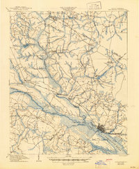
The Tar River serves as the central artery for this coastal plain landscape at the opening of the twentieth century, connecting the port of Washington to the interior settlements of Grimesland and Pactolus. The river is active with transit, marked by a primary Steamboat Route and vital river crossings such as Boyd Ferry and Grimes Ldg. at the Pitt and Beaufort County line. Further downstream, the river widens into the Pamlico River as it passes Chocowinity and the landmark known as The Castle.
Find a feature on this map
71 named features on this map. Tap any name to fly to it.
Don’t see what you’re looking for? This feature index may not catch every label — zoom into the map to look around manually.
Map Details
Editions of this 1903 Chocowinity Map
This is the sole edition of this map. No revisions or reprints were ever made.