
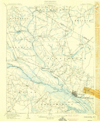
1902 Map of Williamston
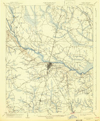
USGS Topo · Published 1944About this map
Roanoke River commerce and inland swamp navigation define this 1902 survey of Martin and Bertie Counties. At this time, the river served as a primary artery for trade, evidenced by numerous historical river access points such as Spellers Ferry Landing, Coniott Landing, and Old Mill Landing. These landings, along with the Steamboat Route, illustrate a landscape where water travel remained vital even as rail lines expanded. Inland, the Atlantic Coast Line railroad connects the growing settlements of Williamston, Everetts, and Hamilton.
Find a feature on this map
46 named features on this map. Tap any name to fly to it.
Don’t see what you’re looking for? This feature index may not catch every label — zoom into the map to look around manually.
Map Details
Editions of this 1902 Williamston Map
This is the sole edition of this map. No revisions or reprints were ever made.
Other maps of this area

1901 · Parmele
USGS Topo · 1:62,500

1901 · Williamston
USGS Topo · 1:62,500

1902 · Parmele
USGS Topo · 1:62,500

1903 · Winterville
USGS Topo · 1:62,500

1903 · Chocowinity
USGS Topo · 1:62,500
1905 · Chocowinity
USGS Topo · 1:62,500
1905 · Winterville
USGS Topo · 1:62,500

1943 · Plymouth
USGS Topo · 1:125,000

1953 · Norfolk
USGS Topo · 1:250,000

1953 · Rocky Mount
USGS Topo · 1:250,000