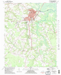
1901 Map of Williamston
USGS Topo · Published 1972About this map
The Roanoke River dominates this 1901 landscape, defining the commerce and boundaries of Martin and Bertie Counties. The river’s winding course is marked by a clear Steamboat Route connecting vital riverfront hubs like Spellers Ferry Landing, Old Mill Landing, and Poplar Point Landing. Inland, the terrain is a complex of wetlands including Broadneck Swamp and the extensive Indian Woods, through which the Atlantic Coast Line R. R. cuts its way toward the port of Williamston. Small agricultural and timber settlements like Everetts and Goldpoint are linked by a network of early roads and a Tramroad, reflecting the turn-of-the-century economy. The survey detail by Albert Pike and T.G. Basinger captures the intricate bends of the river, from Fryingpan Bend to Conine Bend, providing an essential view of the Roanoke basin's maritime and rail development.
Find a feature on this map
50 named features on this map. Tap any name to fly to it.
Don’t see what you’re looking for? This feature index may not catch every label — zoom into the map to look around manually.
Map Details
Editions of this 1901 Williamston Map
This is the sole edition of this map. No revisions or reprints were ever made.
Historical Maps of Williamston Through Time
8 maps found