1905 Map of Winterville
USGS Topo · Published 1942About this map
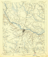
The Tar River serves as the central artery for this region of Pitt County, where a dense network of landings like Blue Banks Ldg. and Redbank Ldg. once facilitated local trade before the full dominance of the rail. The town of Greenville sits at a critical bend in the river, showing a concentrated grid of streets that contrast with the surrounding landscape of swamps and pocosin. To the north, the expansive Grindle Pocosin dominates the terrain, illustrating the natural barriers that shaped early settlement patterns and road placements.
Find a feature on this map
59 named features on this map. Tap any name to fly to it.
Don’t see what you’re looking for? This feature index may not catch every label — zoom into the map to look around manually.
Map Details
Editions of this 1905 Winterville Map
This is the sole edition of this map. No revisions or reprints were ever made.
