
1902 Map of Vanceboro
USGS Topo · Published 1968About this map
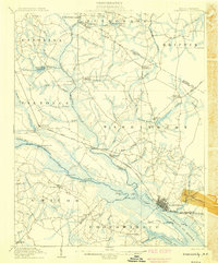
The Vanceboro Ldg. riverfront and the surrounding lowlands of eastern North Carolina define this early 20th-century landscape. Situated along the winding Swift Creek, the settlement of Vanceboro serves as a central hub in a region characterized by expansive wetlands and timber operations. A network of logging infrastructure is evident through multiple industrial tracks, including the Silas Tramroad and several unnamed tramroads that penetrate deep into the Big Pocoson and Reedy Pocoson. These routes suggest an economy heavily reliant on the extraction of resources from the surrounding swamps.
Find a feature on this map
59 named features on this map. Tap any name to fly to it.
Don’t see what you’re looking for? This feature index may not catch every label — zoom into the map to look around manually.
Map Details
Editions of this 1902 Vanceboro Map
This is the sole edition of this map. No revisions or reprints were ever made.
Other maps of this area

1901 · New Bern
USGS Topo · 1:62,500

1902 · Ayden
USGS Topo · 1:62,500

1903 · New Bern
USGS Topo · 1:62,500

1903 · Winterville
USGS Topo · 1:62,500

1903 · Trent River
USGS Topo · 1:62,500

1903 · Chocowinity
USGS Topo · 1:62,500

1904 · Ayden
USGS Topo · 1:62,500

1904 · Trent River
USGS Topo · 1:62,500

1904 · Vanceboro
USGS Topo · 1:62,500
1905 · Chocowinity
USGS Topo · 1:62,500