
1904 Map of Vanceboro
USGS Topo · Published 1936About this map
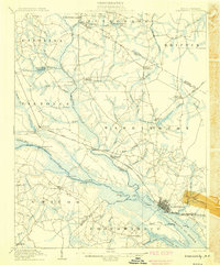
The low-lying wetlands between the Pamlico River and the Neuse River define this coastal plain landscape at the start of the twentieth century. The map highlights a complex network of swampy drainages and pocosons, including the massive Big Pocoson and Reedy Pocoson, which dictated early settlement patterns. Small communities like Vanceboro and Elmira Crossroads are linked by sandy roads, while numerous landings such as Vanceboro Ldg. and Heath Ldg. along the creeks suggest the continuing importance of water-borne transit in an era before modern highway systems.
Find a feature on this map
49 named features on this map. Tap any name to fly to it.
Don’t see what you’re looking for? This feature index may not catch every label — zoom into the map to look around manually.
Map Details
Editions of this 1904 Vanceboro Map
This is the sole edition of this map. No revisions or reprints were ever made.
Other maps of this area

1901 · New Bern
USGS Topo · 1:62,500

1902 · Ayden
USGS Topo · 1:62,500

1902 · Vanceboro
USGS Topo · 1:62,500

1903 · New Bern
USGS Topo · 1:62,500

1903 · Winterville
USGS Topo · 1:62,500

1903 · Trent River
USGS Topo · 1:62,500

1903 · Chocowinity
USGS Topo · 1:62,500

1904 · Ayden
USGS Topo · 1:62,500

1904 · Trent River
USGS Topo · 1:62,500
1905 · Chocowinity
USGS Topo · 1:62,500