
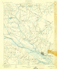
1901 Map of Parmele
USGS Topo · Published 1971About this map
The rail junction at Parmele serves as a central hub in this turn-of-the-century landscape, where the Atlantic Coast Line R. R. intersects with lines extending toward Robersonville and Bethel. This survey, conducted in 1901, reveals a region defined by its intricate drainage and early industrial infrastructure. Agricultural and timber interests are evident through features like the Tram Road and local centers such as Shiloh Mills.
Find a feature on this map
41 named features on this map. Tap any name to fly to it.
Don’t see what you’re looking for? This feature index may not catch every label — zoom into the map to look around manually.
Map Details
Editions of this 1901 Parmele Map
This is the sole edition of this map. No revisions or reprints were ever made.
Other maps of this area

1901 · Williamston
USGS Topo · 1:62,500

1902 · Williamston
USGS Topo · 1:62,500

1902 · Parmele
USGS Topo · 1:62,500

1902 · Tarboro
USGS Topo · 1:62,500

1903 · Tarboro
USGS Topo · 1:62,500

1903 · Winterville
USGS Topo · 1:62,500

1903 · Chocowinity
USGS Topo · 1:62,500

1904 · Falkland
USGS Topo · 1:62,500
1905 · Chocowinity
USGS Topo · 1:62,500
1905 · Winterville
USGS Topo · 1:62,500