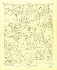
1904 Map of Falkland
USGS Topo · Published 1945About this map
Farmville stands as a primary hub within this 1904 survey of eastern North Carolina, where the agricultural and transport patterns of the early twentieth century are clearly defined. The landscape is deeply influenced by the winding courses of Contentnea Creek and Little Contentnea Creek, which dictate the placement of early settlements and milling sites. Notable industry and logistics are visible through features like the Tugwell Tramroad and the historic Plank Road, indicating the movement of timber and goods across the coastal plain. Rural life is anchored by dispersed post offices and community centers such as Fountain P.O. and Toddy Sta.. The mapping reflects a period when water power was still vital to local economies, as evidenced by Edson Millpond and Harris Millpond. Genealogists will find interest in early township and county boundaries, including the intersection of Pitt and Greene counties, and the locations of small communities like Fieldsboro and Speights Bridge.
Find a feature on this map
50 named features on this map. Tap any name to fly to it.
Don’t see what you’re looking for? This feature index may not catch every label — zoom into the map to look around manually.
Map Details
Editions of this 1904 Falkland Map
3 editions found
Other maps of this area

1901 · Parmele
USGS Topo · 1:62,500

1902 · Parmele
USGS Topo · 1:62,500

1902 · Ayden
USGS Topo · 1:62,500

1902 · Rocky Mount
USGS Topo · 1:62,500

1902 · Tarboro
USGS Topo · 1:62,500

1903 · Tarboro
USGS Topo · 1:62,500

1903 · Winterville
USGS Topo · 1:62,500

1904 · Ayden
USGS Topo · 1:62,500

1904 · Falkland
USGS Topo · 1:62,500

1904 · Rocky Mount
USGS Topo · 1:62,500