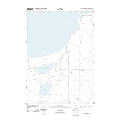
2011 Map of Good Harbor Bay
USGS Topo · Published 2011About this map
Sugarloaf Mountain rises as a central landmark in this Leelanau County landscape, overlooking a series of inland lakes and the expansive coastline of Good Harbor Bay. The settlement patterns of Centerville Township are clearly visible through clusters at Shaldas Corner, Bodus, Schomberg, and Isadore. This 2011 survey documents a community defined by its proximity to water, with Little Traverse Lake and Lime Lake situated just inland from the Lake Michigan shoreline. The presence of numerous burial grounds, including the Swedish Mission Cemetery and Mount Calvary Cemetery, provides a valuable map of early local family lineages and religious denominations. Aviation infrastructure is noted by the Sugar Loaf Resort Airport and Miller-Herroid Airport, reflecting the area's role as a regional destination. A network of creeks like Shetland Creek and Victoria Creek connect the lakes, shaping the drainage and development of this coastal Michigan region.
Find a feature on this map
68 named features on this map. Tap any name to fly to it.
Don’t see what you’re looking for? This feature index may not catch every label — zoom into the map to look around manually.
Map Details
Editions of this 2011 Good Harbor Bay Map
This is the sole edition of this map. No revisions or reprints were ever made.
Other maps of this area

1954 · Traverse City
USGS Topo · 1:250,000

1955 · Cheboygan
USGS Topo · 1:250,000

1957 · Traverse City
USGS Topo · 1:62,500

1957 · Northport
USGS Topo · 1:62,500

1957 · Maple City
USGS Topo · 1:62,500

1958 · Cheboygan
USGS Topo · 1:250,000

1958 · Traverse City
USGS Topo · 1:250,000
1983 · Burdickville
USGS Topo · 1:24,000

1983 · Maple City
USGS Topo · 1:24,000
1983 · Gills Pier
USGS Topo · 1:25,000