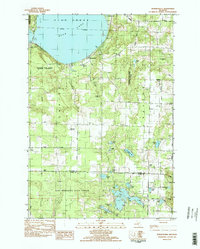
1983 Map of Burdickville
USGS Topo · Published 1984About this map
Glen Lake dominates the northern landscape of this Leelanau County region, where the settlement of Burdickville sits along its southern shore. The 1983 survey reveals a transition between the protected lands of Sleeping Bear Dunes National Lakeshore to the west and the expansive Pere Marquette State Forest to the south. Local life is anchored by institutions like Glen Lake Ch and Glen Lake Sch, while numerous small water bodies including Pearl Lake, Lime Lake, and Armstrong Lake dot the glacial terrain. Genealogists can find several established burial grounds such as Tobin Cem and Rose Hill Cem. The map also captures the local aviation history with the Gainbroke Landing Strip located near the boundary between Empire and Kasson townships.
Find a feature on this map
54 named features on this map. Tap any name to fly to it.
Don’t see what you’re looking for? This feature index may not catch every label — zoom into the map to look around manually.
Map Details
Editions of this 1983 Burdickville Map
3 editions found
Other maps of this area

1954 · Traverse City
USGS Topo · 1:250,000

1954 · Manitowoc
USGS Topo · 1:250,000

1956 · Thompsonville
USGS Topo · 1:62,500

1956 · Frankfort
USGS Topo · 1:62,500

1957 · Empire
USGS Topo · 1:62,500

1957 · Maple City
USGS Topo · 1:62,500

1958 · Traverse City
USGS Topo · 1:250,000

1958 · Manitowoc
USGS Topo · 1:250,000

1976 · Thompsonville NE
USGS Topo · 1:24,000

1976 · Thompsonville NW
USGS Topo · 1:24,000
Featured Places
- Platte Township, MI
- Glen Arbor Township, MI
- Cleveland Township, MI
- Almira Township, MI
- Kasson Township, MI