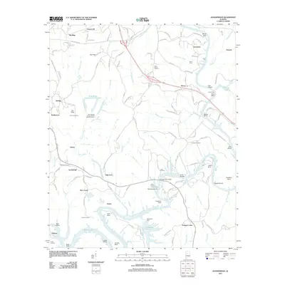
2011 Map of Goodsprings
USGS Topo · Published 2011About this map
The Mulberry Fork of the Black Warrior River dominates this landscape, winding through a complex of bends, shoals, and industrial sites in Walker County. Modern infrastructure and historical transit routes converge at the Copeland Ferry Bridge, while the legacy of energy production is evident in the Strip Mining Impoundment Number 2 and the Rattlesnake Dam near Rattlesnake Lake. The topography is defined by prominent elevations such as Deason Hill, Big Ridge, and Pea Ridge, which separate the river valley from several established settlements.
Find a feature on this map
144 named features on this map. Tap any name to fly to it.
Don’t see what you’re looking for? This feature index may not catch every label — zoom into the map to look around manually.
Map Details
Editions of this 2011 Goodsprings Map
This is the sole edition of this map. No revisions or reprints were ever made.
Other maps of this area

1893 · Jasper
USGS Topo · 1:125,000

1935 · Port Birmingham
USGS Topo · 1:48,000

1938 · Port Birmingham
USGS Topo · 1:62,500

1949 · Cordova
USGS Topo · 1:24,000

1949 · Parrish
USGS Topo · 1:24,000

1949 · Sipsey
USGS Topo · 1:24,000

1949 · Jasper
USGS Topo · 1:24,000

1949 · Tutwiler School
USGS Topo · 1:24,000

1951 · Jasper
USGS Topo · 1:24,000
1951 · Parrish
USGS Topo · 1:24,000