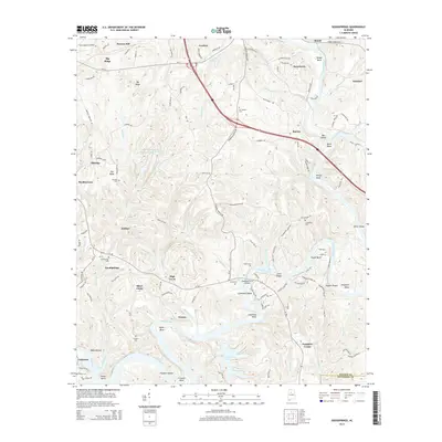
2014 Map of Goodsprings
USGS Topo · Published 2014About this map
The Mulberry Fork snakes through the center of this Walker County landscape, defining a series of dramatic river bends including Copeland Bend and Franklin Bend. This industrial and coal-rich corridor is marked by the presence of Strip Mining Impoundment Number 2 and the settlement of Gorgas, where the river and rail infrastructure of the BNSF Railway meet. The map reveals a dense network of small communities and labor settlements like Goodsprings, Aldridge, and Drifton, many connected by the Cordova Gorgas Rd. Numerous family and community burial grounds, such as Mt Cedrum Cem and Friendship Cem, are tucked away in the hills above the river. The crossing at Copeland Ferry Bridge serves as a vital link over the water, connecting the ridges of Pea Ridge and Big Ridge to the bottomlands near Rattlesnake Lake.
Find a feature on this map
136 named features on this map. Tap any name to fly to it.
Don’t see what you’re looking for? This feature index may not catch every label — zoom into the map to look around manually.
Map Details
Editions of this 2014 Goodsprings Map
This is the sole edition of this map. No revisions or reprints were ever made.
Other maps of this area

1893 · Jasper
USGS Topo · 1:125,000

1935 · Port Birmingham
USGS Topo · 1:48,000

1938 · Port Birmingham
USGS Topo · 1:62,500

1949 · Cordova
USGS Topo · 1:24,000

1949 · Parrish
USGS Topo · 1:24,000

1949 · Sipsey
USGS Topo · 1:24,000

1949 · Jasper
USGS Topo · 1:24,000

1949 · Tutwiler School
USGS Topo · 1:24,000

1951 · Jasper
USGS Topo · 1:24,000
1951 · Parrish
USGS Topo · 1:24,000