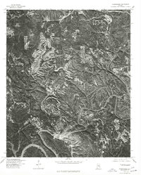
1975 Map of Goodsprings
USGS Topo · Published 1977About this map
The Gorgas industrial site and residential enclave sit prominently along the winding Black Warrior River in this 1970s orthophotoquad. Produced in cooperation with the Soil Conservation Service, the map uses aerial imagery from 1975 to provide a detailed view of the central Alabama coal country, where the landscape is defined by massive surface mining operations. These extensive excavations carve deep into the plateaus, creating a striking contrast against the wooded valleys and the tightly coiled river bends. To the north and west, the smaller settlements of Dovertown and Aldridge represent the worker communities that supported the local extraction and power generation industries during this era of heavy industrial activity in Walker County.
Find a feature on this map
3 named features on this map. Tap any name to fly to it.
Don’t see what you’re looking for? This feature index may not catch every label — zoom into the map to look around manually.
Map Details
Editions of this 1975 Goodsprings Map
This is the sole edition of this map. No revisions or reprints were ever made.
Other maps of this area

1893 · Jasper
USGS Topo · 1:125,000

1935 · Port Birmingham
USGS Topo · 1:48,000

1938 · Port Birmingham
USGS Topo · 1:62,500

1949 · Cordova
USGS Topo · 1:24,000

1949 · Parrish
USGS Topo · 1:24,000

1949 · Sipsey
USGS Topo · 1:24,000

1949 · Jasper
USGS Topo · 1:24,000

1949 · Tutwiler School
USGS Topo · 1:24,000

1951 · Jasper
USGS Topo · 1:24,000
1951 · Parrish
USGS Topo · 1:24,000