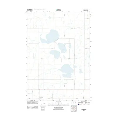
2012 Map of Goodwin
USGS Topo · Published 2012About this map
The town of Goodwin sits in the southwestern corner of this Deuel County landscape, an area defined by a high concentration of glacial prairie potholes and larger water bodies. Significant lakes including Round Lake, Bullhead Lake, and the centrally located Wigdale Lake dominate the terrain, reflecting the post-glacial hydrology of the Coteau des Prairies. This survey captures a rural road network organized along strict section lines, connecting small hubs like Brens Corner and providing access to family-named sites such as Larson Cem. The drainage patterns are clearly visible through the S Fork Yellow Bank River in the northeast and Stray Horse Cr to the west, which navigate the subtle elevation changes of this agricultural region. Genealogists may find the location of Goodwin Cem and Larson Cem particularly useful for tracing local family histories within the township.
Find a feature on this map
28 named features on this map. Tap any name to fly to it.
Don’t see what you’re looking for? This feature index may not catch every label — zoom into the map to look around manually.
Map Details
Editions of this 2012 Goodwin Map
This is the sole edition of this map. No revisions or reprints were ever made.
Other maps of this area

1953 · Milbank
USGS Topo · 1:250,000

1953 · Watertown
USGS Topo · 1:250,000

1958 · Milbank
USGS Topo · 1:250,000

1958 · Watertown
USGS Topo · 1:250,000

1970 · Kranzburg SW
USGS Topo · 1:24,000

1970 · Kranzburg
USGS Topo · 1:24,000

1970 · Bemis
USGS Topo · 1:24,000

1970 · Goodwin
USGS Topo · 1:24,000

1973 · LaBolt
USGS Topo · 1:24,000

1973 · Tunerville
USGS Topo · 1:24,000