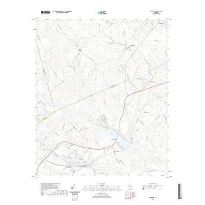
2020 Map of Gordon
USGS Topo · Published 2020About this map
Gordon and Ivey anchor this landscape where the coastal plain meets the Piedmont, a region deeply shaped by kaolin mining and tributary systems. The industrial legacy is visible in large water features like Freeport Kaolin Lake, while Commissioner Creek and Little Commissioner Cr weave through the southern half of the quadrangle. For those researching local families, the map identifies several burial grounds including Union Hill Methodist Cem, Rose Hill Cem, and the Hardie Cem located near the intersection of Hardie Cemetery Rd. Structural landmarks such as McCook Bridge and the Walter A Scott Memorial Bridge provide specific points of reference for the road network. To the north, smaller settlements like Coopers and Pancras sit amidst a complex of creek branches including Gaylord Cr and Black Creek, illustrating the dispersed rural community structure of Wilkinson County.
Find a feature on this map
120 named features on this map. Tap any name to fly to it.
Don’t see what you’re looking for? This feature index may not catch every label — zoom into the map to look around manually.
Map Details
Editions of this 2020 Gordon Map
This is the sole edition of this map. No revisions or reprints were ever made.
Other maps of this area

1912 · Milledgeville
USGS Topo · 1:62,500

1916 · Irwinton
USGS Topo · 1:62,500

1920 · Irwinton
USGS Topo · 1:62,500

1953 · Athens
USGS Topo · 1:250,000

1956 · Gordon
USGS Topo · 1:62,500

1957 · Macon
USGS Topo · 1:250,000

1958 · Macon
USGS Topo · 1:250,000

1958 · Athens
USGS Topo · 1:250,000

1959 · Athens
USGS Topo · 1:250,000

1963 · Athens
USGS Topo · 1:250,000