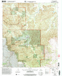
2003 Map of Gorum
USGS Topo · Published 2005About this map
The Kisatchie Hills dominate this section of Central Louisiana, where the high ground of Chopin Camp Ridge and Sunk Hill|Sunk Hill meets the complex drainage of Bayou Barbue and Cypre Bayou. Centered on the settlement of Gorum, this survey reflects a landscape deeply intertwined with the Kisatchie National Forest. The map captures a transition between the rugged, high-relief terrain of the Kisatchie Hills Wilderness and the bottomlands of the various bayous that snake through the parish lines.
Find a feature on this map
37 named features on this map. Tap any name to fly to it.
Don’t see what you’re looking for? This feature index may not catch every label — zoom into the map to look around manually.
Map Details
Editions of this 2003 Gorum Map
This is the sole edition of this map. No revisions or reprints were ever made.
Other maps of this area

1937 · Chopin NE
USGS Topo · 1:31,680

1937 · Chopin SW
USGS Topo · 1:31,680

1937 · Chopin NW
USGS Topo · 1:31,680

1937 · Aloha
USGS Topo · 1:31,680

1937 · Montgomery
USGS Topo · 1:62,500

1937 · Chopin SE
USGS Topo · 1:31,680

1937 · Cloutierville
USGS Topo · 1:31,680

1937 · Cypress
USGS Topo · 1:31,680

1942 · Kisatchie
USGS Topo · 1:62,500

1942 · Montgomery
USGS Topo · 1:62,500