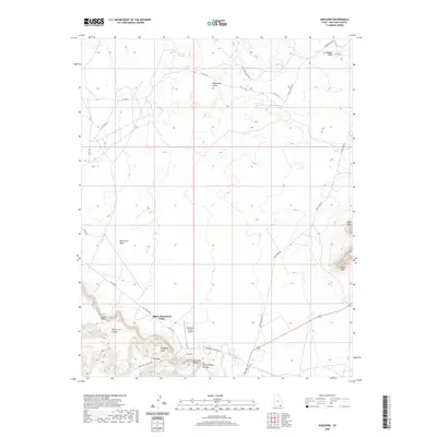
2020 Map of Goulding
USGS Topo · Published 2020About this map
Goulding and the surrounding high desert of San Juan County are centered in this modern topographic study, showcasing the intricate landscape of the Utah-Arizona borderlands. The map details the local infrastructure supporting the community of Oljato-Monument Valley, including the Monument Valley Airport and the network of roads such as Oljato Main Rd and Monument Valley Rd. The terrain is characterized by massive formations and recessed canyons, with named features like Eagle Rock, Eagle Mesa, and Douglas Mesa providing distinct vertical relief. Water sources, vital in this arid environment, are specifically marked at Cedar Spring and Nepalto Spring. Beyond the settlements, the map tracks the winding routes of Monument Wash and the passage through The Gap, illustrating how the geography dictates movement through Horse Trail Canyon and past Goulding Arch.
Find a feature on this map
30 named features on this map. Tap any name to fly to it.
Don’t see what you’re looking for? This feature index may not catch every label — zoom into the map to look around manually.
Map Details
Editions of this 2020 Goulding Map
This is the sole edition of this map. No revisions or reprints were ever made.
Other maps of this area

1883 · Marsh Pass
USGS Topo · 1:250,000

1886 · Henry Mountains
USGS Topo · 1:250,000

1892 · Marsh Pass
USGS Topo · 1:250,000

1892 · Henry Mountains
USGS Topo · 1:250,000

1952 · Clay Hills 4 SW
USGS Topo · 1:24,000

1952 · Clay Hills 3 SE
USGS Topo · 1:24,000

1952 · Agathla Peak 1 NW
USGS Topo · 1:24,000

1952 · Boot Mesa
USGS Topo · 1:62,500

1952 · Clay Hills 4 SE
USGS Topo · 1:24,000

1952 · Agathla Peak 1 NE
USGS Topo · 1:24,000