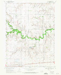
1969 Map of Grafton
USGS Topo · Published 1971About this map
Grafton and Lushton anchor this agricultural survey of the Nebraska plains during the late 1960s. The landscape is defined by the winding course of the West Fork Big Blue River and its tributary, School Creek, which carve through the otherwise structured sections of Henderson and West Blue townships. Transportation history is etched into the terrain, showing the active Burlington Northern line alongside remnants of an Old Grade Railroad, providing a clear look at how rail infrastructure shifted over time. Local family researchers will find value in the placement of Lushton Cem and Greenwood Cem, as well as the transition from York County to Fillmore County. Small-scale industrial activity is noted at the Gravel Pit and municipal facilities like the Sewage Disposal Ponds, reflecting the essential utilities of these rural communities.
Find a feature on this map
18 named features on this map. Tap any name to fly to it.
Don’t see what you’re looking for? This feature index may not catch every label — zoom into the map to look around manually.
Map Details
Editions of this 1969 Grafton Map
This is the sole edition of this map. No revisions or reprints were ever made.
Other maps of this area

1898 · York
USGS Topo · 1:125,000

1899 · York
USGS Topo · 1:125,000

1955 · Lincoln
USGS Topo · 1:250,000

1957 · Lincoln
USGS Topo · 1:250,000

1958 · Lincoln
USGS Topo · 1:250,000
1968 · Henderson
USGS Topo · 1:24,000

1969 · Bixby
USGS Topo · 1:24,000
1969 · Geneva
USGS Topo · 1:24,000

1969 · Fairmont
USGS Topo · 1:24,000
1969 · York South
USGS Topo · 1:24,000