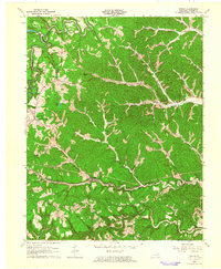
1962 Map of Grahn
USGS Topo · Published 1964About this map
Carter Caves State Park anchors the northwestern corner of this 1962 revision, where the karst topography of Devils Backbone and Box Canyon shapes the path of Tygarts Creek. This area is a focal point for early tourism, featuring Cascade Caves, an Amphitheater, and Smoky Valley Lake. Moving south, the landscape shifts toward the industrial and transport corridor of the Chesapeake and Ohio railroad, which parallels Barrett Creek through the settlements of Grahn and Aden.
Find a feature on this map
45 named features on this map. Tap any name to fly to it.
Don’t see what you’re looking for? This feature index may not catch every label — zoom into the map to look around manually.
Map Details
Editions of this 1962 Grahn Map
This is the sole edition of this map. No revisions or reprints were ever made.
Other maps of this area

1903 · Kenova
USGS Topo · 1:125,000

1904 · Kenova
USGS Topo · 1:125,000

1950 · Bruin
USGS Topo · 1:24,000

1950 · Grahn
USGS Topo · 1:24,000

1950 · Wesleyville
USGS Topo · 1:24,000

1950 · Olive Hill
USGS Topo · 1:24,000

1950 · Ault
USGS Topo · 1:24,000

1950 · Tygarts Valley
USGS Topo · 1:24,000

1953 · Grayson
USGS Topo · 1:24,000

1953 · Oldtown
USGS Topo · 1:24,000