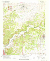
1972 Map of Granby
USGS Topo · Published 1973About this map
George Washington Carver National Monument occupies a significant portion of the northwest quadrant of this survey, marking the site of the scientist’s childhood home along Carver Branch. The surrounding landscape is a study in transitional land use, where the agricultural expanses of Diamond Grove Prairie and Olivers Prairie meet the industrial legacy of local lead and zinc mining. Evidence of this extraction is found in the extensive Tailings piles and multiple Quarry sites scattered near Granby. The transportation network is anchored by the St Louis-San Francisco railroad, which skirts the winding course of Shoal Creek. For genealogists, the map is particularly dense with burial sites including Granby Memorial Cem, Hazelwood Cem, and several smaller family or local grounds like Kenney Cem and Gibson Cem.
Find a feature on this map
40 named features on this map. Tap any name to fly to it.
Don’t see what you’re looking for? This feature index may not catch every label — zoom into the map to look around manually.
Map Details
Editions of this 1972 Granby Map
This is the sole edition of this map. No revisions or reprints were ever made.
Other maps of this area

1886 · Carthage
USGS Topo · 1:125,000

1894 · Carthage
USGS Topo · 1:125,000

1916 · Neosho
USGS Topo · 1:62,500

1921 · Sarcoxie
USGS Topo · 1:62,500

1943 · Ritchey
USGS Topo · 1:62,500

1947 · Joplin
USGS Topo · 1:250,000

1949 · Joplin
USGS Topo · 1:250,000

1954 · Tulsa
USGS Topo · 1:250,000

1954 · Joplin
USGS Topo · 1:250,000

1958 · Joplin
USGS Topo · 1:250,000