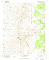
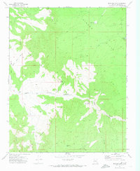
1971 Map of Grand Gulch Bench
USGS Topo · Published 1974About this map
The Grand Gulch Mine and Savanic Mine anchor this high-desert mining landscape, showing the industrial footprint in Mohave County during the early 1970s. Located along the Grand Gulch Bench, the area is defined by a network of drainage systems including Grand Gulch Wash, Gyp Wash, and Pigeon Wash. The presence of the Landing Strip near the mining operations suggests the logistical challenges of this isolated terrain, where transportation relied heavily on a series of Jeep Trails and more primitive Trails weaving through the Cliffs. Water management is represented by small, vital features like Squaw Tank and Eds Pond, while the Cunningham Mine in Cunningham Canyon further illustrates the mineral extraction history that shaped this corner of Arizona. The survey precisely documents the elevation changes from the bench down into the North Fork Pigeon Canyon.
Find a feature on this map
19 named features on this map. Tap any name to fly to it.
Don’t see what you’re looking for? This feature index may not catch every label — zoom into the map to look around manually.
Map Details
Editions of this 1971 Grand Gulch Bench Map
This is the sole edition of this map. No revisions or reprints were ever made.
Other maps of this area

1886 · Mt. Trumbull
USGS Topo · 1:250,000

1892 · Mt. Trumbull
USGS Topo · 1:250,000

1953 · Grand Canyon
USGS Topo · 1:250,000

1957 · Grand Canyon
USGS Topo · 1:250,000

1958 · Grand Canyon
USGS Topo · 1:250,000

1960 · Grand Canyon
USGS Topo · 1:250,000
1971 · Gyp Hills
USGS Topo · 1:24,000
1971 · Olaf Knolls
USGS Topo · 1:24,000
1971 · Pakoon Springs
USGS Topo · 1:24,000
1971 · Mustang Point
USGS Topo · 1:24,000