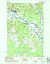
1986 Map of Grand Isle
USGS Topo · Published 1986About this map
The St John River serves as the international boundary between Maine and New Brunswick in this mid-1980s survey, anchoring a landscape defined by riverside settlements and agricultural plains. Along the southern bank, Grand Isle and St David follow the river's curve, while across the water, St Basile and Riviere-Verte mark the Canadian side. The geography is characterized by distinct alluvial features like the Plaine des Smyth and the large Thibodeau Island sitting in the channel. Away from the main waterway, the terrain rises toward the interior of Aroostook Co, where the Little Madawaska River winds through more secluded areas near Germain Lake and Lavels Lake. This map captures the region's cross-border connectivity through the local road network and industrial points like Davis Mill and several Gravel Pits.
Find a feature on this map
27 named features on this map. Tap any name to fly to it.
Don’t see what you’re looking for? This feature index may not catch every label — zoom into the map to look around manually.
Map Details
Editions of this 1986 Grand Isle Map
This is the sole edition of this map. No revisions or reprints were ever made.
Other maps of this area

1927 · Stockholm
USGS Topo · 1:48,000

1927 · Square Lake
USGS Topo · 1:48,000

1931 · Square Lake
USGS Topo · 1:62,500

1931 · Stockholm
USGS Topo · 1:62,500

1932 · Frenchville
USGS Topo · 1:48,000

1935 · Frenchville
USGS Topo · 1:62,500

1938 · Grand Isle
USGS Topo · 1:62,500

1940 · Grand Isle
USGS Topo · 1:62,500

1953 · Stockholm
USGS Topo · 1:62,500

1953 · Square Lake
USGS Topo · 1:62,500