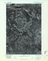
1975 Map of Grand Lake Seboeis SE
USGS Topo · Published 1981About this map
La Pomkeag Lake dominates the northern reaches of this Maine landscape, reflecting the intricate waterways and timberlands of Penobscot County during the mid-1970s. This orthophotoquad, based on aerial photography from October 1975, reveals a network of logging roads and trails that weave between Grand Lake Seboeis and Snowshoe Lake in the southwest. The imagery provides a clear view of the natural drainage patterns, from the winding Umcolcus Stream to the West Branch and the central Carey Lake. Rising above the surrounding lowlands and bogs, McLean Ridge provides a distinct topographic landmark amidst the dense forest. The map captures the region before extensive modern development, preserving the layout of the wilderness as it was used by sportsmen and the timber industry.
Find a feature on this map
8 named features on this map. Tap any name to fly to it.
Don’t see what you’re looking for? This feature index may not catch every label — zoom into the map to look around manually.
Map Details
Editions of this 1975 Grand Lake Seboeis SE Map
This is the sole edition of this map. No revisions or reprints were ever made.
Other maps of this area

1940 · Island Falls
USGS Topo · 1:62,500

1940 · Oxbow
USGS Topo · 1:62,500

1942 · Island Falls
USGS Topo · 1:62,500

1942 · Oxbow
USGS Topo · 1:62,500

1954 · Shin Pond
USGS Topo · 1:62,500

1954 · Grand Lake Seboeis
USGS Topo · 1:62,500

1954 · Presque Isle
USGS Topo · 1:250,000

1958 · Presque Isle
USGS Topo · 1:250,000

1960 · Presque Isle
USGS Topo · 1:250,000
1965 · Oxbow
USGS Topo · 1:62,500