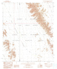
1990 Map of Granite Mountains South
USGS Topo · Published 1990About this map
The Granite Mountains dominate this Sonoran Desert landscape, where the convergence of the Barry M Goldwater Air Force Range and the Cabeza Prieta Wilderness and National Wildlife Refuge marks a unique intersection of military and conservation land use. The topography is defined by the sharp rise of the Bryan Mountains to the southwest and the broad expanses of the Growler Valley and Mohawk Valley. Drainage patterns are dictated by the ephemeral San Cristobal Wash, which cuts a path through the arid lowlands. While much of the terrain is marked as Restricted, rare localized water sources such as the Granite Pass Tank and geographic landmarks like Saguaro Gap provide essential reference points for navigating this unpopulated corner of Pima and Yuma Counties.
Find a feature on this map
14 named features on this map. Tap any name to fly to it.
Don’t see what you’re looking for? This feature index may not catch every label — zoom into the map to look around manually.
Map Details
Editions of this 1990 Granite Mountains South Map
This is the sole edition of this map. No revisions or reprints were ever made.
Other maps of this area

1953 · Ajo
USGS Topo · 1:250,000

1957 · Ajo
USGS Topo · 1:250,000

1958 · Ajo
USGS Topo · 1:250,000

1962 · Ajo
USGS Topo · 1:250,000

1963 · Ajo
USGS Topo · 1:250,000

1964 · Growler Peak
USGS Topo · 1:62,500
1964 · Agua Dulce Mts
USGS Topo · 1:62,500

1965 · O'Neill Hills
USGS Topo · 1:62,500

1965 · Granite Mountains
USGS Topo · 1:62,500

1967 · Ajo
USGS Topo · 1:250,000