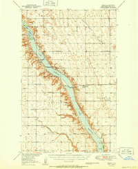
1951 Map of Grano
USGS Topo · Published 1951About this map
Lake Darling dominates the central landscape of this Renville County survey, tracing the path of the Souris River through the heart of the northern plains. The map illustrates a strictly organized rural society divided into townships such as Clay, Hamlet, and Brandon, where the life of the homesteader was anchored by local institutions. Small settlements like Grano and Greene are connected by the Minneapolis Sault Ste Marie railroad line, which served as a vital artery for moving grain and goods. Evidence of a once-dense network of rural education is visible in the numerous numbered schoolhouses and named facilities like Clay Center School and Lockwood School. The terrain is defined by low-lying wetlands and coulees, including Little Deep Creek and Mackobee Coulee, while the Upper Souris National Wildlife Refuge marks the conservation efforts along the river valley.
Find a feature on this map
29 named features on this map. Tap any name to fly to it.
Don’t see what you’re looking for? This feature index may not catch every label — zoom into the map to look around manually.
Map Details
Editions of this 1951 Grano Map
This is the sole edition of this map. No revisions or reprints were ever made.
Other maps of this area

1947 · Tolley
USGS Topo · 1:62,500

1948 · Dokken SW
USGS Topo · 1:24,000

1948 · Mohall
USGS Topo · 1:24,000

1948 · Tolley
USGS Topo · 1:24,000

1948 · Lansford
USGS Topo · 1:62,500

1948 · Burlington
USGS Topo · 1:62,500

1948 · Lansford SW
USGS Topo · 1:24,000

1949 · Tolley SE
USGS Topo · 1:24,000

1949 · Burlington NW
USGS Topo · 1:24,000

1949 · Lansford NW
USGS Topo · 1:24,000