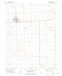
1973 Map of Grant
USGS Topo · Published 1977About this map
Grant serves as the focal point of this Perkins County survey, positioned at the intersection of a significant regional rail corridor and local thoroughfares. The town's layout in the early 1970s is well-defined, showing a central Park and the nearby Fairground, which speak to the community's civic and social organization. Industrial and utility infrastructure is clearly marked, including a Substation south of the town center and Sewage Disposal Ponds situated on the outskirts.
Find a feature on this map
12 named features on this map. Tap any name to fly to it.
Don’t see what you’re looking for? This feature index may not catch every label — zoom into the map to look around manually.
Map Details
Editions of this 1973 Grant Map
This is the sole edition of this map. No revisions or reprints were ever made.
Other maps of this area

1954 · McCook
USGS Topo · 1:250,000

1957 · McCook
USGS Topo · 1:250,000

1958 · McCook
USGS Topo · 1:250,000

1961 · Brandon NE
USGS Topo · 1:24,000

1961 · Lamar NE
USGS Topo · 1:24,000

1961 · Brandon SE
USGS Topo · 1:24,000
1973 · Grant NE
USGS Topo · 1:24,000

1973 · Imperial NE
USGS Topo · 1:24,000
1973 · Imperial NW
USGS Topo · 1:24,000
1973 · Wild Horse Spring
USGS Topo · 1:24,000