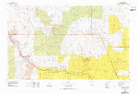
1978 Map of Grants
USGS Topo · Published 1978About this map
The Cibola National Forest and several tribal nations define the landscape of this region during the late 1970s. The Atchison Topeka and Santa Fe RR and Interstate 40 parallel the Rio San Jose, creating a vital transportation corridor through Grants and Milan. Industrial activity is marked by the presence of the Jackpile Mine on the Laguna Indian Reservation, while the high country of the Cebolleta Mountains and Mount Taylor towers over the surrounding mesas. Traditional settlements like San Mateo and Seboyeta are connected by a network of state routes, including New Mexico 53 and New Mexico 279, which navigate the complex terrain of Mesa Chivato and Mesa Gigante (Bell Rock Mesa). This period shows the meeting of historical agricultural communities with large-scale mining and modern interstate transit.
Find a feature on this map
84 named features on this map. Tap any name to fly to it.
Don’t see what you’re looking for? This feature index may not catch every label — zoom into the map to look around manually.
Map Details
Editions of this 1978 Grants Map
2 editions found
Other maps of this area

1883 · Mt. Taylor
USGS Topo · 1:250,000

1886 · Wingate
USGS Topo · 1:250,000

1886 · Mt. Taylor
USGS Topo · 1:250,000

1888 · Bernalillo
USGS Topo · 1:125,000

1889 · Albuquerque
USGS Topo · 1:125,000

1890 · Jemes
USGS Topo · 1:125,000

1892 · Jemes
USGS Topo · 1:125,000

1892 · Wingate
USGS Topo · 1:250,000

1892 · Mt. Taylor
USGS Topo · 1:250,000

1893 · Albuquerque
USGS Topo · 1:125,000