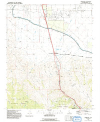
1991 Map of Grapevine
USGS Topo · Published 1992About this map
Grapevine Canyon serves as a critical mountain passage where the southern Central Valley meets the rugged ascent toward the Tejon Pass. This 1991 survey captures the area's infrastructure-heavy landscape, dominated by the Governor Edmund G Brown California Aqueduct as it contours across the valley floor. The map highlights the intersection of transit and history at Grapevine, where modern services sit near the Rose Stage Station Historical Marker, a nod to the era of overland stage travel. To the north, the Tejon Oil Field and various borrow pits illustrate the region's industrial utility, while the southern portion of the map transitions into the protected wilderness of the Los Padres National Forest. The presence of Fort Tejon State Historic Park at the southern edge of the quadrangle marks the site of a 19th-century military outpost established to protect the pass.
Find a feature on this map
35 named features on this map. Tap any name to fly to it.
Don’t see what you’re looking for? This feature index may not catch every label — zoom into the map to look around manually.
Map Details
Editions of this 1991 Grapevine Map
This is the sole edition of this map. No revisions or reprints were ever made.
Other maps of this area

1903 · Mt. Pinos
USGS Topo · 1:125,000

1903 · Tejon
USGS Topo · 1:125,000

1910 · Buena Vista Lake
USGS Topo · 1:125,000

1912 · Buena Vista Lake
USGS Topo · 1:125,000

1914 · Caliente
USGS Topo · 1:125,000

1931 · West of Tejon Hills
USGS Topo · 1:31,680

1931 · Tejon Hills
USGS Topo · 1:31,680

1933 · Tejon Hills
USGS Topo · 1:31,680
1934 · West of Tejon Hills
USGS Topo · 1:31,680
1934 · Coal Oil Canyon
USGS Topo · 1:31,680