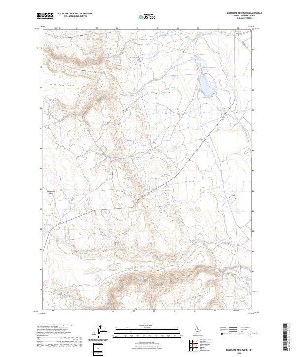
2024 Map of Grasmere Reservoir
USGS Topo · Published 2024About this map
Grasmere Reservoir and its surrounding high-desert plateau define this section of Owyhee County, where water sources are critical landmarks. The landscape is marked by a series of drainages and springs, including Crab Creek, Louse Creek, and the isolated Roll Inn Spring. Higher elevations are represented by the prominent flat-topped Little Blue Table and the Rattlesnake Basin, which guide the flow of seasonal waterways toward the Rattlesnake Reservoir. The area’s aviation history and ranching infrastructure are noted through the presence of the Grasmere Airport and several remote roadways like Rowland Rt Rd and Mt Creek Rd. This modern survey illustrates how traditional landmarks, from Timber Draw to Marys Creek, continue to orient travelers across this expansive Idaho backcountry.
Find a feature on this map
18 named features on this map. Tap any name to fly to it.
Don’t see what you’re looking for? This feature index may not catch every label — zoom into the map to look around manually.
Map Details
Editions of this 2024 Grasmere Reservoir Map
This is the sole edition of this map. No revisions or reprints were ever made.
Other maps of this area

1955 · Jordan Valley
USGS Topo · 1:250,000

1955 · Twin Falls
USGS Topo · 1:250,000

1957 · Jordan Valley
USGS Topo · 1:250,000

1958 · Twin Falls
USGS Topo · 1:250,000

1958 · Jordan Valley
USGS Topo · 1:250,000
1971 · Riddle
USGS Topo · 1:24,000

1972 · Wickahoney Point
USGS Topo · 1:24,000

1972 · Little Blue Table
USGS Topo · 1:24,000
1979 · Antelope Creek
USGS Topo · 1:24,000

1979 · Blackstone Reservoir
USGS Topo · 1:24,000