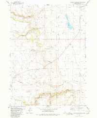
1979 Map of Grasmere Reservoir
USGS Topo · Published 1980About this map
Grasmere Reservoir and the high desert landscape of Owyhee County define this late 1970s topographic record. The map reveals an area where water management and ranching represent the primary human footprints, anchored by the Hart Ranch and Tindall Ranch. A network of unpaved infrastructure, including an extensive system of Jeep Trails and a designated Grasmere Landing Strip, connects these isolated outposts across the high plains.
Find a feature on this map
38 named features on this map. Tap any name to fly to it.
Don’t see what you’re looking for? This feature index may not catch every label — zoom into the map to look around manually.
Map Details
Editions of this 1979 Grasmere Reservoir Map
This is the sole edition of this map. No revisions or reprints were ever made.
Other maps of this area

1955 · Jordan Valley
USGS Topo · 1:250,000

1955 · Twin Falls
USGS Topo · 1:250,000

1957 · Jordan Valley
USGS Topo · 1:250,000

1958 · Twin Falls
USGS Topo · 1:250,000

1958 · Jordan Valley
USGS Topo · 1:250,000
1971 · Riddle
USGS Topo · 1:24,000

1972 · Wickahoney Point
USGS Topo · 1:24,000

1972 · Little Blue Table
USGS Topo · 1:24,000
1979 · Antelope Creek
USGS Topo · 1:24,000

1979 · Blackstone Reservoir
USGS Topo · 1:24,000