
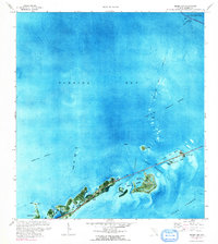
1971 Map of Grassy Key
USGS Topo · Published 1973About this map
Grassy Key and its neighboring islands are depicted in this early 1970s orthophotomap, showing the delicate balance of the Middle Keys' geography before further modern expansion. This unique survey combines aerial photography with topographic data, revealing the intricate water systems of Florida Bay and the Hawk Channel. The transportation corridor is anchored by the Long Key Viaduct, which links Conch Key to the northeast. Notable development on Duck Key is visible, including its distinct canal system and golf course.
Find a feature on this map
28 named features on this map. Tap any name to fly to it.
Don’t see what you’re looking for? This feature index may not catch every label — zoom into the map to look around manually.
Map Details
Editions of this 1971 Grassy Key Map
2 editions found
Other maps of this area

1971 · Marathon
USGS Topo · 1:24,000

1971 · Long Key
USGS Topo · 1:24,000

1971 · Crawl Key
USGS Topo · 1:24,000

1972 · Marathon
USGS Topo · 1:24,000

1972 · Bamboo Key
USGS Topo · 1:24,000

1972 · Schooner Bank
USGS Topo · 1:24,000

1972 · East Bahia Honda Key NE
USGS Topo · 1:24,000

1972 · Buchanan Keys
USGS Topo · 1:24,000

1983 · Islamorada
USGS Topo · 1:100,000

1983 · Key West
USGS Topo · 1:100,000