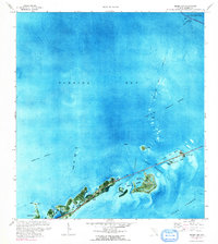
1971 Map of Grassy Key
USGS Topo · Published 1991About this map
Florida Bay dominates the northern half of this orthophotomap, showing the complex aquatic environment of the Middle Keys in the early 1970s. The map illustrates the linear development along the Overseas Highway, where small island communities like Conch Key and Grassy Key are linked by significant engineering works like the Long Key Viaduct. The transition from the natural landscape of Everglades National Park at the northern edge to the increasingly developed terrain of Duck Key is evident, particularly with the inclusion of a Golf Course and a Sewage Disposal site on the latter. This survey provides a precise look at the hydrography of the era, marking the Intracoastal Waterway and the various banks and passes, such as Channel Key Pass, that define the shallow waters between the keys and the deeper Hawk Channel to the south.
Find a feature on this map
30 named features on this map. Tap any name to fly to it.
Don’t see what you’re looking for? This feature index may not catch every label — zoom into the map to look around manually.
Map Details
Editions of this 1971 Grassy Key Map
2 editions found
Other maps of this area

1971 · Grassy Key
USGS Topo · 1:24,000

1971 · Marathon
USGS Topo · 1:24,000

1971 · Long Key
USGS Topo · 1:24,000

1971 · Crawl Key
USGS Topo · 1:24,000

1972 · Marathon
USGS Topo · 1:24,000

1972 · Bamboo Key
USGS Topo · 1:24,000

1972 · Schooner Bank
USGS Topo · 1:24,000

1972 · East Bahia Honda Key NE
USGS Topo · 1:24,000

1972 · Buchanan Keys
USGS Topo · 1:24,000

1983 · Islamorada
USGS Topo · 1:100,000