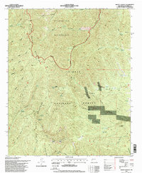
1995 Map of Grassy Lookout
USGS Topo · Published 1998About this map
San Mateo Mountains dominate the landscape in this central New Mexico survey, which reflects the complex overlay of conservation and industry in the late twentieth century. The map centers on the high-altitude terrain of the Cibola National Forest and the protected Withington Wilderness. A significant industrial footprint is visible at the Rosedale Mine and Bell Mine, where features such as Tailings and a Cyanide Tank suggest a history of precious metal extraction. The presence of Grassy Lookout and several water management points like Park Well and Lake Spring indicate the essential infrastructure required for forest management and livestock in this arid environment. Traces of early surveying remain in the alignment of the First Standard Parallel South, cutting across a network of canyons including Potato Canyon and Big Rosa Canyon.
Find a feature on this map
62 named features on this map. Tap any name to fly to it.
Don’t see what you’re looking for? This feature index may not catch every label — zoom into the map to look around manually.
Map Details
Editions of this 1995 Grassy Lookout Map
This is the sole edition of this map. No revisions or reprints were ever made.
Other maps of this area

1954 · Tularosa
USGS Topo · 1:250,000

1958 · Tularosa
USGS Topo · 1:250,000

1964 · Welty Hill
USGS Topo · 1:24,000

1964 · San Juan Peak
USGS Topo · 1:24,000

1964 · Bay Buck Peaks
USGS Topo · 1:24,000

1964 · Blue Mountain
USGS Topo · 1:24,000
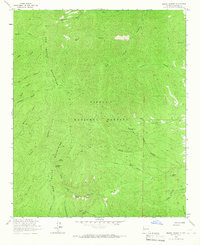
1964 · Grassy Lookout
USGS Topo · 1:24,000

1964 · Monica Saddle
USGS Topo · 1:24,000
1965 · Tenmile Hill
USGS Topo · 1:24,000
1965 · Squaw Peak
USGS Topo · 1:24,000