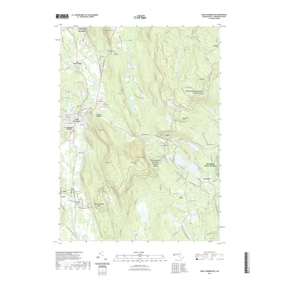
2021 Map of Great Barrington
USGS Topo · Published 2021About this map
Great Barrington sits as the central hub of this landscape, where the Housatonic River winds southward through a valley flanked by prominent peaks. To the north, the industrial character of the region is evident in settlements like Housatonic and Risingdale, while the village of Van Deusenville marks an older established node near the river's bend. The eastern half of the map is dominated by the steep rises of East Mtn and Warner Mtn, crossed by the long-distance Appalachian National Scenic Trail. Local heritage is anchored by sites such as Saint Peters Cem and Elmwood Cem, alongside smaller hamlets like Hartsville. Recreational and natural features including Lake Buel and the Berkshire Trout Hatchery illustrate the area's transition into a destination for outdoorsmen and conservation, while Butternut Basin highlights the importance of the local topography for regional recreation.
Find a feature on this map
127 named features on this map. Tap any name to fly to it.
Don’t see what you’re looking for? This feature index may not catch every label — zoom into the map to look around manually.
Map Details
Editions of this 2021 Great Barrington Map
This is the sole edition of this map. No revisions or reprints were ever made.
Other maps of this area

1885 · Sheffield
USGS Topo · 1:62,500

1886 · Becket
USGS Topo · 1:62,500

1888 · Sheffield
USGS Topo · 1:62,500

1888 · Becket
USGS Topo · 1:62,500

1888 · Sandisfield
USGS Topo · 1:62,500

1888 · Pittsfield
USGS Topo · 1:62,500

1890 · Pittsfield
USGS Topo · 1:62,500

1891 · Sheffield
USGS Topo · 1:62,500

1893 · Becket
USGS Topo · 1:62,500

1893 · Sheffield
USGS Topo · 1:62,500