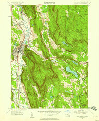
1946 Map of Great Barrington
USGS Topo · Published 1958About this map
Great Barrington sits at a geographic crossroads in the late 1940s, where the Housatonic River and the Ny Nh & H Rr define the valley floor. To the east, the landscape rises sharply into the high ridges of Beartown Mtn, where the Mt Wilcox Fire Tower overlooks the deep waters of Lake Buel. This survey captures the rural infrastructure of the era, noting a dense network of one-room schoolhouses like the Pitcher Sch, Boardman Sch, and Brush Hill Sch serving outlying farms and settlements such as Hartsville and Risingdale.
Find a feature on this map
55 named features on this map. Tap any name to fly to it.
Don’t see what you’re looking for? This feature index may not catch every label — zoom into the map to look around manually.
Map Details
Editions of this 1946 Great Barrington Map
This is the sole edition of this map. No revisions or reprints were ever made.
Other maps of this area

1885 · Sheffield
USGS Topo · 1:62,500

1886 · Becket
USGS Topo · 1:62,500

1888 · Sheffield
USGS Topo · 1:62,500

1888 · Becket
USGS Topo · 1:62,500

1888 · Sandisfield
USGS Topo · 1:62,500

1888 · Pittsfield
USGS Topo · 1:62,500

1890 · Pittsfield
USGS Topo · 1:62,500

1891 · Sheffield
USGS Topo · 1:62,500

1893 · Becket
USGS Topo · 1:62,500

1893 · Sheffield
USGS Topo · 1:62,500