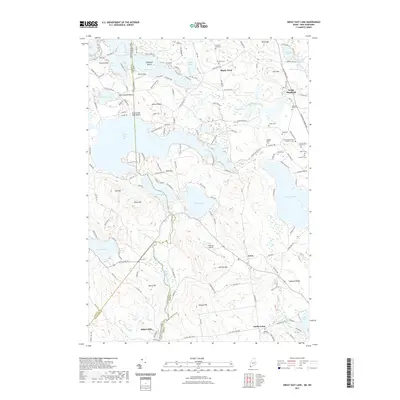
2021 Map of Great East Lake
USGS Topo · Published 2021About this map
Great East Lake anchors this borderland landscape, straddling the line between Maine and New Hampshire. The 2021 topography reveals a complex network of glacial water bodies, including Lovell Lake, Square Pond, and Wilson Lake, which have long shaped the settlement patterns of York and Carroll counties. In the southern reach, the village of Milton Mills sits near the confluence of Salmon Falls River and Miller Brook, reflecting a historic reliance on water power for local industry. The map captures a transition from waterfront leisure areas like Great East Lake Beach and Shady Nook to the elevated terrain of Gile Mtn and Bond Mtn. Genealogists will find a high density of family-named burial sites, such as the Abagail Patch Cem and Welch Cem, scattered among the ridges. Unique transportation markers like Nadeau's Airport near Acton further document the modern character of this rural New England district.
Find a feature on this map
109 named features on this map. Tap any name to fly to it.
Don’t see what you’re looking for? This feature index may not catch every label — zoom into the map to look around manually.
Map Details
Editions of this 2021 Great East Lake Map
This is the sole edition of this map. No revisions or reprints were ever made.
Other maps of this area

1891 · Berwick
USGS Topo · 1:62,500

1891 · Newfield
USGS Topo · 1:62,500

1893 · Berwick
USGS Topo · 1:62,500

1893 · Newfield
USGS Topo · 1:62,500

1919 · Alton
USGS Topo · 1:62,500

1928 · Wolfeboro
USGS Topo · 1:62,500

1933 · Berwick
USGS Topo · 1:48,000

1933 · Newfield
USGS Topo · 1:48,000

1937 · Newfield
USGS Topo · 1:62,500

1937 · Berwick
USGS Topo · 1:62,500