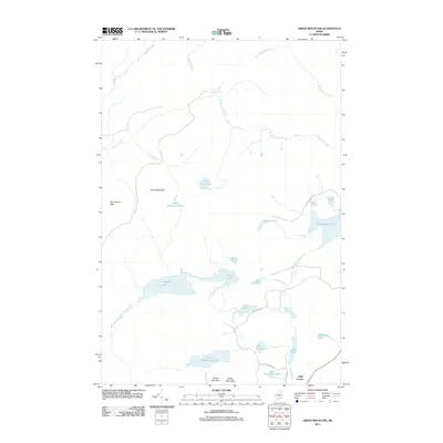
2011 Map of Green Mountain
USGS Topo · Published 2011About this map
The West Branch Mattawamkeag River flows through this remote Penobscot County landscape, anchoring a complex system of interconnected waterways. In the south, the settlement at Halls Corner provides a point of human reference amidst the timbered terrain of Green Mountain and Pickett Mountain. The topography is defined by its glacial heritage, featuring a dense concentration of lakes and ponds, from the sizeable Pleasant Lake and Rockabema Lake to smaller, high-elevation bodies like Green Mountain Pond. Historical access to the interior is traced through primitive roads such as Rockabema Rd and McDonald Rd, which wind through the Lane Brook Hills. This survey documents a wilderness character maintained into the early 21st century, where drainage patterns like Weeks Brook and West Hastings Brook dictate the layout of the land.
Find a feature on this map
32 named features on this map. Tap any name to fly to it.
Don’t see what you’re looking for? This feature index may not catch every label — zoom into the map to look around manually.
Map Details
Editions of this 2011 Green Mountain Map
This is the sole edition of this map. No revisions or reprints were ever made.
Other maps of this area

1940 · Island Falls
USGS Topo · 1:62,500

1940 · Oxbow
USGS Topo · 1:62,500

1942 · Island Falls
USGS Topo · 1:62,500

1942 · Oxbow
USGS Topo · 1:62,500

1954 · Shin Pond
USGS Topo · 1:62,500

1954 · Grand Lake Seboeis
USGS Topo · 1:62,500

1954 · Presque Isle
USGS Topo · 1:250,000

1958 · Presque Isle
USGS Topo · 1:250,000

1960 · Presque Isle
USGS Topo · 1:250,000
1965 · Oxbow
USGS Topo · 1:62,500